Showing posts with label Tennessee State Parks. Show all posts

Friday, October 14, 2016

Men's Retreat 2016 at Montgomery Bell State Park

For the 3rd year in a row, our church (New Song Christian Fellowship) held its annual Men's Retreat at Montgomery Bell State Park. And of course, I opted to camp in the park campground instead of staying in the park inn. For the past 2 years, I have been able to get a campsite on the creek. You can read about last year's rainy weekend here: Men's Retreat at Montgomery Bell.

That Friday, I got off work early and headed out to the park to give me enough time to check in, get set up, cook dinner, and then head to the Friday evening worship service at the Inn and Conference Center. Unlike last year, Aaron was able to join me at the retreat. However, he had a mandatory cross country practice after school - so he caught a ride out to the park with some friends. This year, I reserved site 106, which was a lot roomier than the site I reserved last year. I arrived at the park around 3:30pm and quickly backed the trailer into the site and got things set up. That gave me plenty of time to have a relaxing dinner and head to the 7:00 worship service.

The guys that Aaron got a ride with didn't reserve a site in time, so I offered to let them "squat" on our site - which is completely legal. Each site allows 1 tent along with the RV, and a total of 8 people. After service, we headed back to camp, and the guys set their tent up (in the dark) between our trailer and the creek. After a few hours around the campfire, we all turned in for the night.

The morning worship service was scheduled for late in the morning to purposely give everyone the opportunity to spend some quality time with the Lord and have a relaxing breakfast.

Our campsite on Saturday morning - with the guys' tent set up behind our camper.
The creek behind our campsite offered a great place for some quiet time with the Lord.
After a relaxing morning, we all headed back to the conference center for our Saturday morning worship service. As with all our services, our morning session started out with a powerful time of worship.


Aaron had a cross country meet in nearby Dickson, TN. This particular meet was the championship meet for the Mid State Cross Country Association, so it was not a meet that could be missed. Because of that, we had to leave the worship service early in order to get to the meet.

Despite being in the middle of October, it was actually a pretty warm day - with temperatures in the 80s by the time Aaron ran.

Aaron, with the rest of the Summit High varsity team at the starting line.
...And they're off!
Aaron charging up the last big hill on the course before heading to the finish line.
Despite the sun and warm temperatures, Aaron actually did pretty well. After the meet was over, we grabbed some quick lunch and headed back to camp.

By the time we got back to camp, the men's retreat was over, and the guys had cleared out their gear and headed home.
After a long-hot day at the meet, we decided to relax a little...
Aaron getting in some "chill time" after his meet.
After relaxing around camp for a while, we decided to go on a short hike before dinner. We hopped on the blue-blazed Wildcat trail at the back of the campground and headed toward the iron ore pits and Cumberland Presbyterian birthplace memorial.
The Cumberland Presbyterian Memorial Chapel


A replica of Rev. Samuel McAdow's home, where the Cumberland Presbyterian Church was founded some 200+ years ago.
After our short hike, we headed back to camp to cook dinner. After dinner, we enjoyed some time around a small campfire before heading in for the night.
The next morning, we got up early, showered, had a quick breakfast, and packed up camp in time to head out to join our Church for Sunday morning prayer and Worship service.

Montgomery Bell State Park is probably our most frequently visited state park for good reason: It's within an hours drive from home and is probably one of Tennessee's nicest parks. It's perfect for a quick retreat and a relaxing weekend.

Friday, May 27, 2016

2nd Annual End-of-School Backpacking Adventure

Last year, I took my son and a couple of his friends on a short overnight backpacking trip to celebrate the end of the school year. To read about our trip last year, click here. He and his friends enjoyed it so much, they decided to make it a yearly tradition. This year, Aaron invited one more person along:
Our hiking party: From the left - Aaron, Nick, Josiah, and James
South Cumberland State Park is a large state park made up of several non-contiguous natural areas. Last year, we hiked the Westernmost section of the Savage Gulf area, near the Stone Door Ranger Station. This year, for a change of scenery, we decided to hike the Easternmost section of Savage Gulf.
The plan was to park the truck at the Savage Gulf Ranger Station and hike the Savage Day Loop trail to Savage Falls. From there, we would pick up the South Rim trail and hike to the Stagecoach Road Campground. After camping one night at the campground, we would hike back out (retracing our steps) the next morning.
Normally, I take my DSLR camera with me on our adventures. This time out, I made a big amateur-level mistake: I packed all my camera gear, but left the camera battery in the charger at home. Thankfully, I discovered this at the ranger station before we set off on the hike; and left my useless gear in the truck instead of bringing that extra weight along. Because of my absent-minded lapse, all of the following pictures were taken on my iPhone.

Tennessee State Parks, South Cumberland State Park, Savage Gulf
After arriving at the Ranger Station and unloading the truck, we headed off on our adventure.
Tennessee State Parks, South Cumberland State Park, Savage Gulf
After about a mile along the Savage Day Loop trail, we came to a suspension bridge crossing Savage Creek. The bridge only allowed 2 people to cross at a time, so Aaron and James went first...
Tennessee State Parks, South Cumberland State Park, Savage Gulf
...Followed by Josiah and Nick.
Tennessee State Parks, South Cumberland State Park, Savage Gulf
Being the last in our party to cross, I stopped in the middle of the bridge and snapped a picture of Savage Creek. It's hard to believe this little creek carved the gorge that we were hiking along.
Tennessee State Parks, South Cumberland State Park, Savage Gulf
Mountain Laurel in bloom along the trail.
Tennessee State Parks, South Cumberland State Park, Savage Gulf
After about another half-mile, we came to Savage Falls. This is taken from the top of the falls, looking West into the gorge. The creek flows through a small cleft in the limestone to form the falls. There is a small splinter trail that leads to the base of the falls. At this point, we off-loaded our packs and descended a wooden staircase to enjoy the falls.
Tennessee State Parks, South Cumberland State Park, Savage Gulf
Savage Falls
Tennessee State Parks, South Cumberland State Park, Savage Gulf
We found some wildlife basking in the sun around the Savage Falls pool. It wasn't poisonous, but we gave it plenty of space anyway.
Tennessee State Parks, South Cumberland State Park, Savage Gulf
The boys enjoyed exploring the creek and climbing on the rocks.
Tennessee State Parks, South Cumberland State Park, Savage Gulf

After we got our fill of Savage Falls, we donned our packs once again and began heading to the top of the gorge via the South Rim trail.

Tennessee State Parks, South Cumberland State Park, Savage Gulf
Once we climbed to the top of the plateau, we found a scenic overlook to stop at for lunch. The South Rim trail has several overlooks along the 4+ miles between Savage Falls and the campground. However, none of them are directly on the trail. Overlooks are marked by short, blue-blazed splinter trails along the main path.
Tennessee State Parks, South Cumberland State Park, Savage Gulf
View from the overlook, looking West into the gorge.
Tennessee State Parks, South Cumberland State Park, Savage Gulf
Another view, looking North across the gorge. During lunch, we saw a few hikers on the rock outcropping hiking the North Rim trail.
After lunch, we hit the trail again and headed toward the Stagecoach Road campground. Being early in the hiking season, the trail was pretty overgrown in sections - either because this trail is less traveled than others, or because the maintenance crew hadn't been out to clear the trail of overgrowth yet. One thing was for sure: it was definitely the season for ticks - and the overgrown trail gave plenty of ticks the opportunity to find us. A few of the boys kept finding ticks and flicking them off throughout our trip.

One way to make a 45-year old man feel old, is to make him try to keep up with a group of athletic teenage boys. I thought I was moving at a pretty good pace, but the boys quickly left me in their dust.

Tennessee State Parks, South Cumberland State Park, Savage Gulf
I finally caught up to them when they stopped to take in the view from one of the last overlooks off the trail.
Tennessee State Parks, South Cumberland State Park, Savage Gulf
Looking Northeast across Savage Gulf.
Tennessee State Parks, South Cumberland State Park, Savage Gulf
Looking Northeast
Tennessee State Parks, South Cumberland State Park, Savage Gulf
While we had the opportunity, we went for the obligatory scenic group photo
 From the overlook, it was only a few more minutes of hiking to reach the campground. The Stagecoach Road Campground has 10 sites, some bigger than others. Site 2 is actually a group site and costs more to reserve. All other sites are $8 a night (plus a reservation fee). Not knowing how big our party was going to be, I reserved 2 sites (site 8 and 9). Site 8 was a little bigger than site 9, so we decided to setup camp there.

Tennessee State Parks, South Cumberland State Park, Savage Gulf
We quickly got to work setting up camp: pitching our tents and gathering wood. Within short time, we had a proper campsite.
The water source for the campground is a small spring located right at the beginning of the campground trail. This area was actually in a moderate drought, due to a unusually dry Spring. Because of that, most of the water was stagnant. We spent a few minutes looking up and down the spring and finally found a place where water was bubbling up from the ground. We made a small make-shift dam with some rocks and used that small pool as our water source.

After gathering enough water for our stay, we headed back to camp and cooked our dinner. After dinner, we built our fire and conducted our ceremonial burning of the Geometry workbooks. Before it got too dark, the boys went for a short exploratory walk around the campground. By 9:30, we were all tucked into our tents for the night.

The next morning, we all struck camp, had breakfast, filled up our water bottles, and headed back to the ranger station by 10 am. We made pretty quick time heading back, hiking all 6 miles without any stops. All the while, the boys were talking about fast food and trying to decide where we would stop for lunch. In case you were wondering - Taco Bell won the discussion.

All-in-all, the boys had a great time, and are already looking forward to next year's trip.

Friday, April 22, 2016

Natchez Trace State Park

Each Spring, we usually take a short family camping trip over a weekend to get the RV out of hibernation, de-winterize it, and make sure everything is in working order. This spring, we decided to go to Natchez Trace State Park. The park is less than a 2-hour drive from our house, and has several campgrounds - one being a full-service RV park on one of the park's 3 lakes (which is a rarity among Tennessee State Parks).

Tennessee State Parks, Natchez Trace State Park
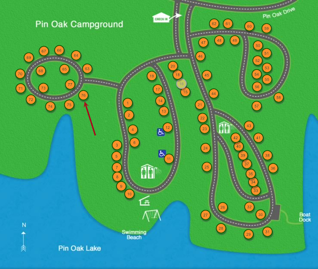
Pin Oak RV Campground is located on Pin Oak Lake, near the South end of the park. We reserved site 76, the last "lake side" site available for the weekend.
Tennessee State Parks, Natchez Trace State Park, Venture RV, Sonic SN220VBH, Honda Ridgeline
Site 76 is in a quiet circle, right beside one of the fingers of the lake. The campsites are quite roomy, fully equipped with electricity, water, sewer, fire ring, and charcoal grill. There is no cable or wi-fi available, but we were able to pick up several Jackson, TN area TV stations using our aerial antenna.
While there are things to do at Natchez Trace State Park (hiking, fishing, mountain biking), I was actually looking for a peaceful weekend without any pressing agenda. Our quiet and spacious site on the lake helped to make that wish a reality. Most of the families with younger kids were camped closer to the swimming beach and playground, so our morning was peaceful and slow-paced. After breakfast, Aaron and I rode our bikes up to the Pin Oak Lodge to check it out and get some park maps.

For lunch, we "brown-bagged" some sandwiches and chips, walked over to the covered picnic pavilion near the swimming area, and enjoyed a relaxing lunch with a view of the lake.

We saw a little "wildlife" in the park. The campground had its own flock of Canadian geese that wandered around looking for scraps to eat - and you can always count on seeing a squirrel here and there. 
Our daughter had to work a shift that Saturday morning. After getting off work, she drove out to the park to meet up with us that afternoon. Once she arrived, we drove up to the Cub Lake area of the park, which boasts a swimming beach, recreation lodge, a couple of tent campgrounds, and hiking trails. Our short excursion provided a perfect opportunity to shoot some photos of the area:

A purple martin resting on a wire inside the boat house.
The bumble bees were out in force.
A martin house right by the swimming beach.
Tennessee State Parks, Natchez Trace State Park, Cub Lake Recreation Area
Walking bridge across Cub Lake.
A spider staking out territory on the bridge.
Tennessee State Parks, Natchez Trace State Park, Cub Lake Recreation Lodge, Cub Lake Swim Beach
The Cub Lake recreation area has a boat house with Pedal Boats and Jon Boats for rent. However, boat rentals don't open until Memorial Day, and are open through Labor Day.
After we got our fill of the Cub Lake area, we headed back to camp to get ready for dinner and prepare the fire pit for our obligatory camp fire. Tennessee State Parks ban the burning of any non-native firewood. If you don't live in the area and don't have access to a private stash of native wood, firewood can be purchased at the Pin Oak Lodge for $5 a bundle.

Tennessee State Parks, Natchez Trace State Park, Pin Oak RV Campground
After getting the hamburgers off the grill; Haley, Aaron, Angel the dog, and I quickly headed into the woods behind our campsite to see if we could catch the sun setting over the Lake. We weren't quick enough to catch the sun sinking below the horizon, but we were able to catch a little bit of color in the sky after the sun had set.
Check out time at the campground is a generous 12:00 noon - so the next morning, we were still able to have a relaxing morning, taking our time packing up before the deadline.

All-in-all, we really enjoyed our stay at Natchez Trace State Park. It's not a terribly long drive to the park, the campground is nice, and the sites are spacious with a nice view of the lake. I'm sure we will revisit the park again soon.

Sunday, March 20, 2016

Backpacking the Cumberland Trail - Signal Point to North Suck Creek

Recently, I learned about the on-going project to complete the Cumberland Trail. I had also promised my son a Spring-time backpacking trip to test out some of the camping gear he got for Christmas. So, on the first free weekend in March, he and I headed down to the Southern terminus of the trail in Signal Mountain, Tennessee. Like a master sculptor, the Tennessee River and its tributaries have carved mountains out of the lower end of the Cumberland Plateau, creating the Tennessee River Gorge - Tennessee's own version of the Grand Canyon. Our plan was to hike the Signal and Edwards Points Section of the trail along the Tennessee River Gorge.

The plan: Hike in from the Signal Point Trailhead, and set up camp at the North Suck Creek campsite, 7 miles up the trail - then strike camp the next morning and hike back out.
Cumberland Trail, Signal Point, Signal Mountain, Tennessee River Gorge
This section of the Cumberland Trail begins at Signal Point on Signal Mountain. Signal Point was controlled by Union Troops during the Confederate siege of Chattanooga. It was here that Union Troops were able to maintain communications despite Confederate blockades around the city. In this picture, Aaron is looking South, Southeast toward Chattanooga with Raccoon Mountain and Lookout Mountain in the distance.
Cumberland Trail, Signal Point, Tennessee River Gorge
Looking North-west from Signal Point.
Cumberland Trail, Tennessee River Gorge, Signal Point, Signal Mountain
The Cumberland Trail trailhead. North Suck Creek Bridge is our destination.
Cumberland Trail, Tennessee River Gorge, Middle Creek Gorge, Signal Mountain
The first mile of the trail, which was pretty rocky, took us around the edge of Signal Mountain into the Middle Creek Gorge. About 20 minutes in, we came across a clearing in the trees where we could look across Middle Creek Gorge and see Julia Falls in the distance.
Cumberland Trail, Middle Creek Gorge, Signal Mountain
After about a mile and a half, we completed our descent into Middle Creek Gorge and arrived at the Middle Creek Bridge.
Cumberland Trail, Middle Creek Bridge, Teton Sports, Signal Mountain
Aaron crossing Middle Creek Bridge
Cumberland Trail, Middle Creek Gorge, Signal Mountain
After crossing Middle Creek, we started a mile-long ascent up the other side of Middle Creek Gorge. The ascent by itself is pretty challenging. When you have a 40-pound backpack strapped to you, it's really difficult. About half-way up the gorge, we came across a clearing at the base of a couple of natural "arches." 
The ascent up Middle Creek Gorge
Cumberland Trail, Middle Creek Gorge, Signal Mountain
Near the top of the gorge is Lockhart's Arch. The arch is named after 3 boy scout brothers who discovered the arch while seeking a route out of the gorge. 
The Cumberland Trail, Signal Mountain, Tennessee River Gorge
After a couple of hours of challenging hiking, we finally made it to Edwards Point. Edwards Point is right on the Tennessee River, on the other side of the Middle Creek Gorge. This was our planned lunch stop - so we unloaded our packs, got out our bagged lunch, and relaxed while we enjoyed the view.
The Cumberland Trail, Edwards Point, Signal Mountain, Tennessee River Gorge
Aaron enjoying the view.
The Cumberland Trail, Signal Mountain, Raccoon Mountain, Suck Creek Gorge
After Edwards Point, the trail turns North, leaves the Tennessee River, and heads into the Suck Creek Gorge. Across the gorge are the multi-colored bluffs of Raccoon Mountain, giving the area a "Grand Canyon" look and feel.
The Cumberland Trail, Signal Mountain, Suck Creek Gorge
Looking South down Suck Creek Gorge toward Raccoon and Lookout Mountain.
The Cumberland Trail, Signal Mountain, North Suck Creek Gorge
After a four-mile hike into the Suck Creek Gorge, along the edge of the plateau, across several smaller creeks; we finally came to Mushroom Rock. Mushroom Rock is a 20-foot high sandstone pedestal rock that has been naturally eroded into the shape of a mushroom. From Mushroom Rock, the trail makes a sharp descent into the gorge to the North Suck Creek bridge and campground.
The Cumberland Trail, North Suck Creek Bridge
The North Suck Creek campground is situated at the east base of the North Suck Creek Bridge. Aaron and I found a nice clearing and set up camp, right off the trail, beside the bridge. Technically, the Cumberland Trail ends here. Future plans have the trail continuing further North along the creek.
The Cumberland Trail
Across the bridge, it is another mile and a half to Suck Creek Rd/Hwy 27 and Prentice Cooper State Forest
North Suck Creek
Camping by the creek was nice and afforded a convenient and plentiful source of water. After the sun went down, we climbed in our tents, slipped into our sleeping bags, with hopes of staying warm during the 30° night.
The next morning, we had a hearty breakfast, struck camp, loaded up our packs, and headed back up the gorge for our 7-mile hike back to the truck.
Signal Mountain, Rainbow Lake Wilderness Area
After crossing back over Middle Creek, instead of heading back to Signal Point, we headed up a spur trail that took us past the Rainbow Lake spillway to the Rainbow Lake parking area where our truck was parked.

All-in-all, though challenging for the 45 year-old body, hiking this short portion of the Cumberland Trail was enjoyable. I look forward to exploring other portions of the trail in the future.